Search Results
projects found for
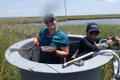
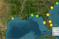
Nekton Monitoring
Historic amounts of oil and contaminants were released into marine and coastal environments of the northern Gulf coast as a result of the DWH oil spil...

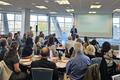
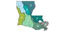
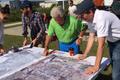
Enhancing the Resilience of Southeast Louisiana’s Asian American Fishing Communities
Asian American fisherfolk in the region have faced a series of natural and human-made disasters in recent decades, including Hurricane Katrina in 2005...

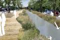
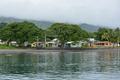
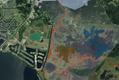
Bayou Bienvenue Wetland Triangle Restoration Project
Prior efforts by the U.S. Army Corps of Engineers, the EPA, and the Coastal Wetlands Planning, Protection, and Restoration Act (CWPPRA) have laid impo...
Social Determinants of Health Data Integration Barriers in Nueces County, Texas
Despite the impact SDOHs have on health outcomes, it is not well understood how data on the conditions in which people live, grow, work and age can be...
Nature Based Solutions at MacDill Air Force Base
The natural configuration of the AFB provides significant opportunities to employ nature-based solutions, actions inspired by nature that rely on inco...

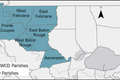
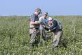
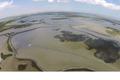
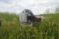
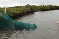
Lower Trophic Level Monitoring for Barataria Basin
Lower trophic level (LTL) organisms represent the base of the food web. In Louisiana’s estuaries these can consist of: wetland vegetation, phytoplan...

ANCHOR THE BAYOU
ANCHOR the Bayou is Bayou Community Foundation’s grassroots initiative to listen, learn, and take action on the challenges and opportunities facing re...
Integrating Natural Flood Protection into Community Based Catastrophe Insurance: Coastal Louisiana Phase One Pilot
Coastal Louisiana’s communities are experiencing more intense and frequent coastal hazards. Within days after an acute flood event occurs, low and mod...

Franklin Area Community-Based Catastrophe Insurance Pilot
The Center has received funds to pilot flood parametric insurance in St. Mary Parish with a focus on the areas in and around Franklin, LA. This will p...


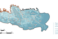
Upper Barataria Marsh Ecological Monitoring
The Upper Barataria Marsh Creation Project is a 1,200-acre restoration initiative in Louisiana's Barataria Basin designed to restore wetland, coastal...

Goma Graveline Insurance
With funding support from the Gulf of Mexico Alliance, we are undertaking a pilot project in Dauphin Island, Alabama, to understand how marsh restorat...


Resilient East Biloxi
Residents of East Biloxi have faced significant impacts from both natural and human-made climate disasters, which have continuously strained the area,...

Advancing Coastal Resilience Through Public-Private Partnerships in Walton County, FL
Like many coastal areas along the Gulf of Mexico, northwest Florida has been experiencing flooding exacerbated by sea level rise, as well as tropical ...
Incorporating Equity and Social Vulnerability Into the Design of Flood Risk Mitigation Strategies
Too often, the development of solutions to climate-related environmental problems depends on purely measurable datasets and models which can give a fe...
Defining the Environmental Benefits of Dredged Sediments in Benefit-Cost Ratio Calculation
Storms, sea level rise, subsidence, disruptions to sediment supply, and other natural and anthropogenic disturbances are driving coastal erosion, habi...
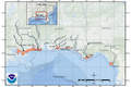
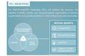
FEMA Cooperating Technical Partner (CTP)
With more than 20,000 communities across the country involved in the National Flood Insurance Program, there is a challenge in making sure flood hazar...
Avian Monitoring
In 2010, the Deepwater Horizon explosion resulted in the largest oil spill in United States history discharging millions of barrels of oil into the Gu...
Mobile, Ala. Resilience Assessment and Plan
Like other coastal cities, Mobile, Alabama is facing unprecedented change from sea-level rise and more frequent and more extreme weather events. To en...

Enhancement of Seagrass at the Chandeleur Islands, Louisiana
The management team working to restore the Chandeleur Islands must make decisions on project design and monitoring in the face of multiple uncertainti...
National Offshore Sand Inventory (NOSI) Assets and Application
Over decades of offshore sand exploration, the BOEM MMP and its collaborators and predecessors have invested millions of dollars in identifying and ca...

Sustainable Sand Stewardship at The Water Institute
Sand and other types of sediment are the building blocks of land, forming the underlying foundation of all communities and ecosystems. Storms, sea lev...
Lake Borgne Gulf Sturgeon Monitoring and Habitat Characterization
Gulf sturgeon’s range includes areas of the northern Gulf of Mexico including Lake Pontchartrain and the Pearl River system extending east to the Suwa...

Integrated modeling to answer complex water/land interaction questions
Addressing how water and land interact, particularly when dealing with large-scale and complex systems, is essential for evaluating how projects will ...

Compound Flooding
The impacts of flooding transcend geospatial boundaries and is the most severe of natural disasters, accounting for billions in damages every year in ...

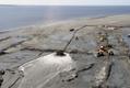
Cumulative effects of restoration on barrier islands and shorelines
Evaluation of coastal restoration project outcomes is mostly commonly focused at the project scale, and there are uncertainties and gaps in understand...
Evaluating Forecasts of Coastal Change
There are several uncertainties in understanding and forecasting the impacts of storms on the barrier islands and coasts of the northern Gulf. For thi...

Cape Lookout National Seashore Storm Characterization
North Carolina State University (NCSU) led the development of a decision-support framework, the Optimal Preservation (OptiPres) tool, to support NPS i...

Environmental Data and Model Catalog (EnDMC)
Organizations that commission the development of environmental models face several practical data management challenges: Once models and simulation o...
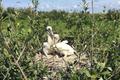
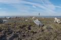
Guidance for Coastal Ecosystem Restoration and Monitoring to Create or Improve Bird-Nesting Habitat
The Water Institute was tasked by the Louisiana Trustee Implementation Group to develop a guidance that could help answer the question, “How can coast...
Long-term strategic water sustainability plan
The Capital Area Ground Water Conservation District (CAGWCC) was created by the Louisiana Legislature through Act 678 of 1974 due to concerns in the r...
Quantifying Blue Carbon in Coastal Louisiana Wetlands for Potential Accreditation
Recent research on coastal wetlands indicates they play an important role in the global carbon cycle and have the potential to be an important compone...

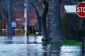
Evaluating and communicating stormwater risk in New Orleans
The City of New Orleans faces significant challenges in managing rainfall under current and future conditions. Present-day challenges include an inade...

Assessing climate-related disturbations and change on phytoplankton community compositions and hypoxia using color remote sensing
Ocean color remote sensing has revolutionized our understanding of coastal ecosystems processes by providing continuous mapping important biogeochemic...
Developing a harmful algal bloom threat index
Harmful algal blooms (HABs) in estuarine waters are those phytoplankton species that can produce a wide range of deleterious impacts to aquatic ecosys...
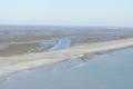
Barrier Island Topographic State: Indicators of Resistance vs Resilience
The LA TIG Monitoring and Adaptive Management (MAM) Strategy has identified a need for barrier island creation, restoration, and maintenance (resilien...


U.S. Army Corps of Engineers (USACE) Research and Development Strategy
The U.S. Army Corps of Engineers (USACE) has a trusted history of developing innovative solutions to the Nation’s toughest engineering challenges. Sin...

Louisiana FloodID
Louisiana is prone to damaging floods through tropical systems, heavy rainfall, or a combination of the two, known as compound flooding. In 2021, The ...
Enhancing Benefits Evaluation for USACE Water Resources Projects
Currently, the benefit-cost analysis (BCA) places a substantial emphasis on the dollar value of the properties a proposed project would protect. Howev...
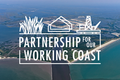
Partnership for Our Working Coast
In 2016, the Greater Lafourche Port Commission (GLPC) formally announced its plans to obtain federal regulatory approval to deepen Belle Pass and the ...
Advancing Offset-Enabling Technology for Blue Carbon Sequestration
Since the last major freeze event in south Louisiana (1989), black mangroves (Avicennia germinans) have been expanding into the salt marshes typically...
City of Jacksonville Resilience Strategy
EVOLVING CHALLENGES REQUIRE NEW APPROACHES Jacksonville is a rapidly growing city. Its vast land area and diverse industries, along with mainstays li...

Texas General Land Office (GLO) Combined River Basin Flood Studies
The Water Institute has partnered since 2020 with the RBFS East Region Study Vendor (Gannett Flemming Transystems or GFT) as a subconsultant to perfor...
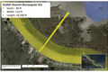
The Bay Denesse Living Lab
Despite the evident and urgent need for tools and techniques that can be deployed in diversion outfall areas to optimize sediment retention, the issue...
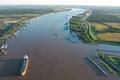
Lowermost Mississippi River Management Program
The Mississippi River has been traditionally managed under three separate “business lines”: Navigation, flood protection, and ecosystem restoration. A...

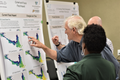
Connecting Local Knowledge and Scientific Understanding
Between 1932 and 2010, Louisiana’s coastal area lost more than 1,800 square mile of land through a variety of means including erosion, subsidence, lac...
Lower Trophic Level Inventory
In April 2010, the Deepwater Horizon offshore oil platform exploded resulting in the most massive oil spill in American history. As part of the respon...
Chincoteague Inlet Modeling Study (CIMS)
The region surrounding Chincoteague Inlet and adjacent Chincoteague, Assateague, and Wallops islands is a dynamic system experiencing rapid change ass...
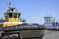
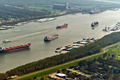
SmartPort
Safe and efficient navigation on the Mississippi River is vital to the U.S. economy and the movement of goods. Louisiana’s five ports on the Lower Mis...

Louisiana Climate Action Plan
Governor John Bel Edwards established the Climate Initiatives Task Force (Task Force) by executive order in August 2020, launching Louisiana’s first-e...

NOAA Damage Assessment, Remediation and Restoration Program (DARRP)
In June 2019, the National Oceanic and Atmospheric Administration (NOAA) Restoration Center announced a five-year cooperative agreement with The Water...
Louisiana Watershed Initiative
Rather than making decisions based on city or parish boundaries, Louisiana recognized that floods are not limited by these artificial lines. As a resu...
Quilmes-Rio de la Plata Research Project Risk and Resilience in Coastal Louisiana
The city is considering two major projects that will critically impact its future: The development of the coastal fringe and the work along the two “a...
Barataria-Terrebonne Estuary System Climate Change Adaptation Plan 2020
Coastal land loss in Louisiana, despite the best efforts of scientists, planners, and residents, is expected to continue. According to the State of Lo...
U.S. Army Corps of Engineers (USACE) Southwestern Division (SWD) Civil Works Strategic Plan
The Institute led a team with partners ILSI/Arcadis to aid the U.S. Army Corp of Engineers (USACE) Galveston District (SWG) in conducting a Strengths,...

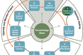
Southeast Conservation Adaptation Strategy (SECAS)
The goal of the Southeast Conservation Adaptation Strategy (SECAS) is to improve the health, function, and connectivity of southeastern ecosystems by ...

Coastal Carbon Sinks
In August 2020, Governor John Bel Edward signed two climate change related executive orders with the first designed to improve coastal resilience by b...
System-Wide Assessment and Monitoring Program (SWAMP)
Since the early 1990s, a number of project-specific monitoring efforts have been established by state agencies and other entities. Comprehensive monit...
Louisiana Coastal Neotectonics and Subsidence Expert Panel
The Water Institute of the Gulf assembled an expert panel composed of recognized experts in the fields of neotectonics/subsidence and geomorphic/sedim...

FEMA Cooperating Technical Partners Special Project: Flood Insurance Public Service Announcements
The Institute is a FEMA Cooperating Technical Partner (CTP) for FEMA Region 6 and the State of Louisiana. The Institute’s CTP Program Management activ...
Louisiana Barrier Island System Management (BISM): Structured Decision-Making
There has been a multidecadal effort in Louisiana to restore these rapidly degrading barrier islands, which has been effective in preserving and prote...

Flood Risk Awareness System Development
Probabilistic weather forecasts provided to the public – e.g., a 30% chance of heavy rain showers that will likely causes localized flooding - are dif...
Louisiana Adaptive Management Status and Improvement Report: Vision and Recommendations
While the idea of using adaptive management as part of coastal restoration work has been around for years, it is complicated to implement. There are m...

Houston's Resilience Strategy
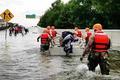
On Aug. 25, 2017, the Category 4 Hurricane Harvey made landfall in Texas causing widespread damage and flooding. According to the Harris County Flood ...

City of Covington: Flood Response Plan Development
In March 2016, heavy rainfall events created severe flash flooding in the city, prompting city leaders to look for a new approach in order to prepare ...
Dutch Dialogues® Charleston
Situated on a peninsula between two rivers and exposed on a third side to the Atlantic Ocean, Charleston, South Carolina, is increasingly exposed to n...
Connecting local knowledge and scientific understanding
Between 1932 and 2010, Louisiana’s coastal area lost more than 1,800 square mile of land through a variety of means including erosion, subsidence, lac...
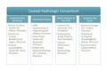
Coastal Hydrologic Consortium
The Consortium intends to jointly develop, pursue and complete research projects that advance the science, engineering, modelling and understanding of...
Statewide Water Resources Framework
Louisiana isn’t normally known for a lack of water, but there are several aquifers around the state where demand has highlighted the need for better i...
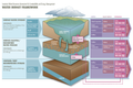
Planning for ecosystem-based adaptation in the Pacific island countries
Pacific island countries and territories are highly vulnerable to climate change. In the next few decades, these countries will face increasing threat...
NWF Barataria Salinity Project
Understanding the historical temporal and spatial patterns of salinity in the Barataria Basin is important not only to better understand and manage th...
Supporting the Working Coast
Land loss, sea level rise, subsidence, and storms increasingly threaten the economic sustainability of Gulf coastal areas at a time when populations a...

National Center for EEcological Analysis and Synthesis (NCEAS) and Science for Nature and People Partnership (SNAPP) – Coastal Restoration Working Group
Conservation and development challenges around the world are complicated and cross the arbitrary borders between ecological conservation and sustainab...
RESTORE Act Center of Excellence for Louisiana
In the wake of the 2010 Deepwater Horizon disaster in the Gulf of Mexico, Congress passed the Resources and Ecosystem Sustainability, Tourist Opportun...
The Natural Classroom Project
Bayou Gross Tete-Grand Bayou is impaired for both fish and wildlife propagation – due to problems with amounts of dissolved oxygen, nitrate/nitrite, t...

Mid-Barataria Engineering Modeling Support
In 2015, The Water Institute of the Gulf developed a basin-wide model for the Louisiana Coastal Area, which was applied to study various scenarios wit...
Lower Barataria Basin and Lower Breton Sound Sediment Diversion Feasibility Study
Diversion site selection required new in-depth knowledge of the morphodynamic and water constituent transport properties in both the lower river syste...
Hydrodynamic modeling for the Fritchie Marsh
This project was intended to gain insight into the hydrodynamics of Fritchie Marsh, a wetland system on the North Shore of Lake Pontchartrain region w...
“This is your shield…this is your estuary”
Although coastal restoration and protection is sometimes thought to only require technical input, coastal communities around the world also hold valua...
Looking for blue crab preferences in a changing coastal environment
Despite coastal land loss, Louisiana’s coastline and estuaries support some of the most productive and economically important fisheries in the Gulf of...
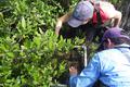
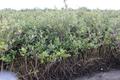
Impact of black mangrove expansion in coastal Louisiana
With fewer winters experiencing extended periods of freezing temperatures, the black mangrove has been expanding in south Louisiana for the past 20 ye...
Relationships between salinity and short-term soil carbon accumulation rates from marsh types across a landscape in the Mississippi River Delta
Many of Louisiana’s coastal wetlands depend upon the annual cycle of birth and death of plant material to help build up soil height as a way of trying...

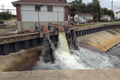
Calcasieu Ship Channel salinity control project
The Calcasieu Ship Channel connects the Gulf of Mexico to the Port of Lake Charles, but it also serves as a conduit for salt water to move into Calcas...
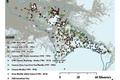
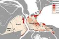
Identifying how communities respond to disasters
Although there has been good work (see the Louisiana Coastal Atlas) on defining when and where Louisiana’s residents have moved throughout the state o...
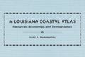
A Louisiana Coastal Atlas: Resources, Economies, and Demographics
Although tropical storms loom large in Louisiana’s history and in dictating population shifts over time, it really only tells a small portion of the s...
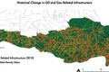
Identifying the vulnerability of critical infrastructure
When storm surge and extreme rainfall events innundate an area of coastal Louisiana, it’s not just homes and businesses that receive damage. Critical ...
Development and application of a hydrological model in the Anahuac National Wildlife Refuge
In 2011, an extended drought in southeastern Texas led to elevated salinity levels in a number of locations throughout the Anahuac National Wildlife R...
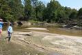
Tracing Amite River sediment in the wake of the August 2016 flood
A heavy rain turned into a deluge in August 2016, ultimately resulting in more than 19 inches of precipitation falling in Baton Rouge and more than 31...
Finding the right flow
Estuaries, wetlands, and swamps depend upon the constant inflow of fresh water to sustain the ecosystem’s balance of plants and animals as well as pro...
Projects
Read more...
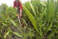
Transport Thresholds for Fine Sediment in Vegetation
The primary objective of this project was to develop a standardized data collection methodology for monitoring fine sediment transport and retention w...