FloodID®: Because Impact Starts With Understanding
FloodID® is a comprehensive, web-based flood forecasting and decision support system purpose-built for emergency managers. Developed to support needs identified in collaboration with state and local government emergency managers, FloodID® enables proactive decision-making before, during and after flood events through delivery of localized impact forecasts, real-time nowcasts, and post-event assessments.
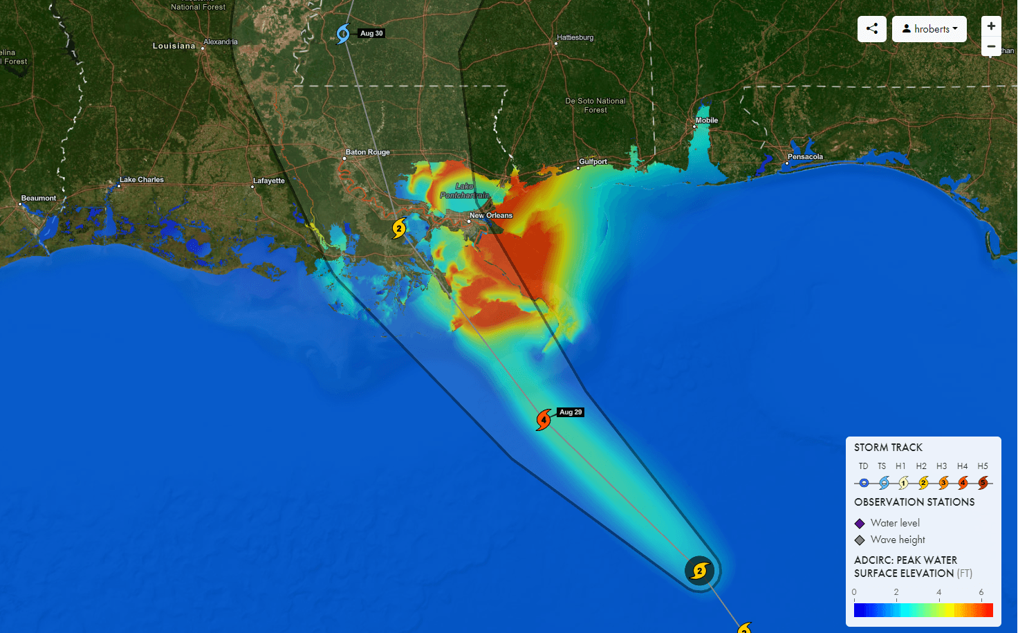
Image: FloodID® generated forecast for hurricane induced storm surge
The FloodID® dashboard streamlines access to high resolution data and decision-support tools that enable critical actions during a flood event, including:
- Evacuation planning
- Rescue operations
- Supply positioning
- Infrastructure protection
- Flood infrastructure operations
- Road closures
- Flood barrier deployment
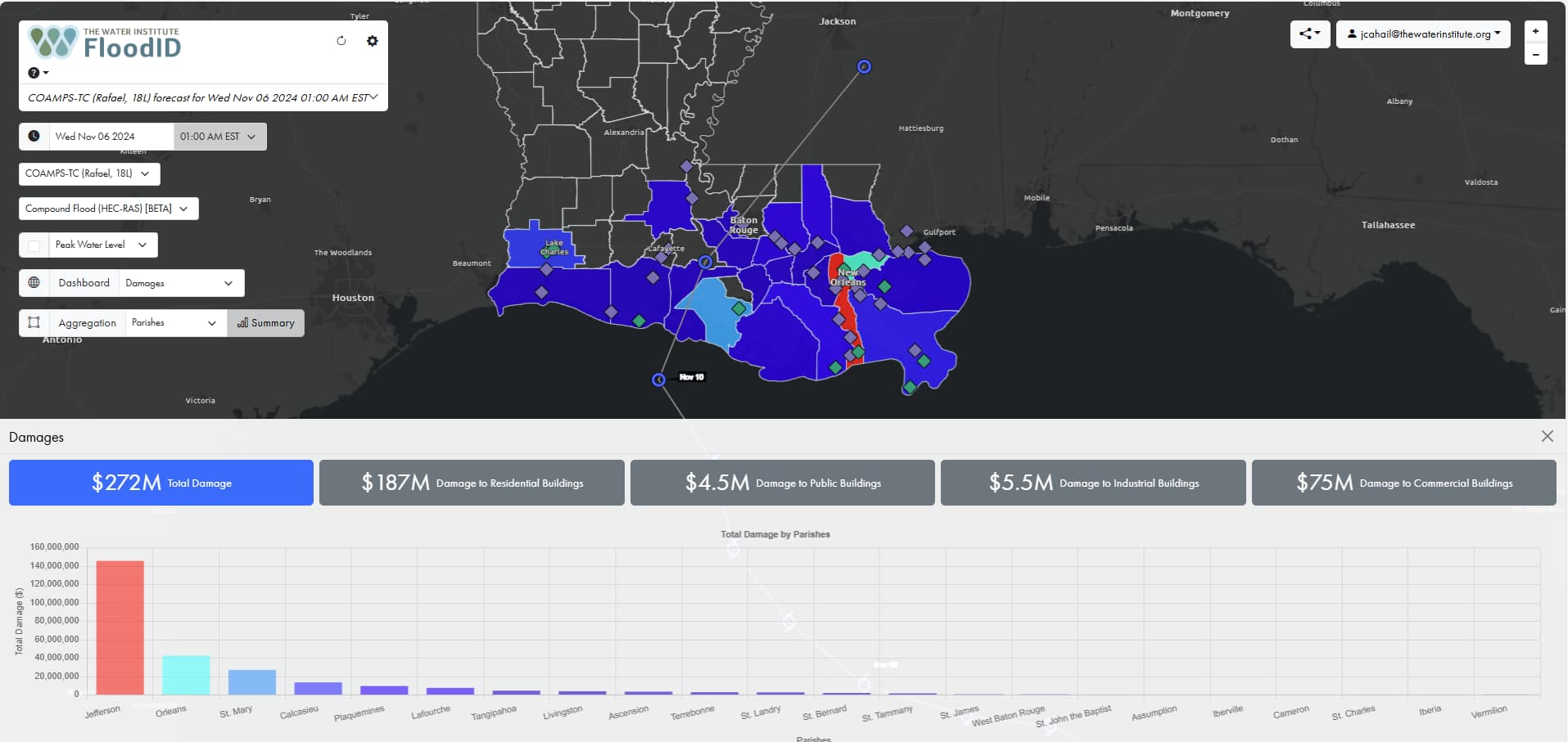
Image: Example FloodID® decision dashboard approximating damages to buildings and contents
FloodID® is uniquely designed to support government and private sector users across a range of use cases and geographies due to unique platform design that delivers:
- End-to-end functionality: From automated data retrieval to meteorological forecast and observation data, to visualizing flood data within decision support dashboards, FloodID® ensures that everything you need to make a decision lives in the same, easy-to-access user interface.
- Affordability: FloodID® was developed with limited budgets of local, regional, and state agencies in mind to ensure delivery of risk-based, reliable flood intelligence to those who need it most.
- Interoperability: The FloodID® system integrates seamlessly with external datasets and platforms, either by incorporating external datasets within the FloodID® dashboard itself or by supplying data from the FloodID® system to external dashboards and pre-existing workflows via API connection.
- Scalability: Powered by our next-generation hybrid machine learning framework, physical model, and statistical physics, the FloodID® system minimizes dependence on local sensors while maintaining forecast accuracy across diverse geographies, meteorological conditions, and hydrological characteristics
- Versatility: Regardless of your location, FloodID® supports access to flood intelligence across inland and coastal regions, including ungauged headwaters, within a single, easy-to-use system.
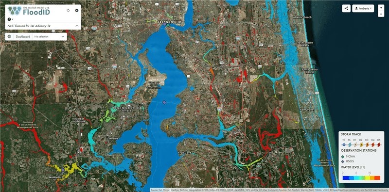
Image: FloodID® generated compound flood forecast accounting for pluvial, riverine and coastal effects along the South Atlantic coast
The FloodID® system enables operational flood intelligence for three distinct types of flooding: coastal, riverine, and pluvial. This advanced technology approach enables information in areas where compound flooding exists, as well as in ungauged areas, such as headwater catchments.
The FloodID® system can display three critical flood intelligence data layers:
- Forecast, showing where floodwaters will be ahead of a flood event. This information can be produced with a forecast horizon of up 120 hours ahead of time, with data feeds refreshed every six hours.
- Nowcast, showing where floodwaters currently are. Currently available upon request.
- Hindcast, showing where floodwaters were during a flood event. Currently available upon request.
Pricing is available upon request, based upon your organization, requirements, and geography. To request a demo or learn more, say hello at sales@floodid.org or fill out the contact form below:
FloodID® is powered by The Water Institute, an independent, non-profit, applied research institution advancing science and developing integrated methods to solve complex environmental and societal challenges.