RFP1 Funded Projects
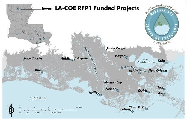
On June 22, 2017, The RESTORE Act Center of Excellence for Louisiana announced almost $3 million in funding through the first RFP process to support 13 research, collaborative, and graduate studentship projects. All projects were completed by the fall of 2020 and the details of those awards, results, reports, and data as well as how this research can inform Louisiana Coastal Protection and Restoration’s Coastal Master Pan are provided below.
A memorandum summarizing the success metrics for RFP1, and how those metrics are calculated, is available here.
For information about upcoming grant opportunities, visit our Funding Opportunities page.
Final Reports
All final technical reports from RFP1 projects are publicly available and can be found below.
Available data
All data, collected data products, and metadata resulting from RFP1 projects will be publicly available within two years after project completion. Data will be available in a regional or national digital repository or data center (i.e., National Centers for Environmental Information, Inter-university Consortium for Political and Social Research, DataOne Dash) that promotes discovery and long-term preservation. You can find links to data below for each project.
Publications
All publications are available on the LA-COE Google Scholar page.

PROJECTS
Coupling hydrologic, tide, and surge processes to enhance flood risk assessments for the Louisiana Coastal Master Plan
Award: $499,882
PI: Scott Hagen, Professor & Director, Louisiana State University Center for Coastal Resiliency (LSU CCR)
Co-Investigators: Matthew Bilskie, LSU CCR; John Atkinson, ARCADIS; Donald Resio, University of North Florida
In the wake of the August 2016 floods in southeastern Louisiana, officials were concerned about the potential consequences of a tropical storm making landfall on already saturated soils and a flooded landscape. This project seeks to understand the compound effect of rainfall with storm surge on flooding in low-lying coastal areas as defined by flood transition zones. This modeling tool can be especially important for the assessment of Coastal Master Plan projects in low gradient coastal regions and is the basis for all work that will be done within flood transition zones under the Louisiana Watershed Initiative.
An evaluation of faulting in Holocene Mississippi River Delta strata through the merger of deep 3D and 2D seismic data with near surface imaging and measurements of vertical motion at three study areas
Award: $349,174
PI: Mark Kulp, Associate Professor of Earth and Environmental Sciences and Director of Coastal Research Laboratory, University of New Orleans
Co-Investigators: Nancye Dawers, Tulane; Rui Zhang, University of Louisiana at Lafayette; David Culpepper, The Culpepper Group; John Lopez, The Pontchartrain Conservancy; Kevin Yeager, University of Kentucky
South Louisiana contains a number of faults, some of which could extend to the surface which would be essential to know during the planning of coastal restoration projects since these surface-impacting faults could impact how land subsides locally. This project is meant to bridge the gap between deep seismic data collected through oil and gas exploration and the surface faulting. The team worked to determine things like slip rates, whether these faults have had impacts near the surface, and assess impacts to infrastructure by mapping elevation changes along roads that cross the faults.
Assessment of coastal island restoration practices for the creation of brown pelican nesting habitat
Award: $299,733
PI: Paul Leberg, Professor in Department of Biology, University of Louisiana at Lafayette
Co-Investigator: Jordan Karubian, Tulane University
Restoration efforts on coastal islands, such as barrier islands, can significantly impact the seabirds who rely on the habitat they provide. This project worked to understand the effects of restoration efforts on the suitability of coastal islands as seabird sites for breeding, nesting, and foraging, and how changes in vegetation and predator communities impact seabird colony success. This research has many potential implications for the Louisiana Coastal Master Plan, for example, these results can be used to improve habitat suitability models for the Brown Pelican in the upcoming and future Coastal Master Plan.
From adapting in place to adaptive migration: Designing and facilitating an equitable relocation strategy
Award: $295,338
PI: Marla Nelson, Associate Professor Planning and Urban Studies, University of New Orleans
Co-Investigators: Traci Birch, LSU Coastal Sustainability Studio; Anna Brand, University of California Berkley; Renia Ehrenfeucht, University of New Mexico
As sea levels encroach upon Louisiana’s coasts and threaten coastal communities, difficult decisions about adaption and, in some extreme cases, relocation, must be considered. This project worked to understand how households adapt and respond to increasing environmental vulnerability, as well as the role of public officials in facilitating and supporting equitable relocation. In order to better understand the challenges and identify innovative practices, interviews were conducted with Terrebonne Parish residents and officials, and past policies and programs were reviewed.
Enhancing sediment retention rates of receiving basins of Louisiana sediment diversions
Award: $292,495
PI: Kehui (Kevin) Xu, Associate Professor, Department of Oceanography and Coastal Sciences, Louisiana State University (LSU)
Co-Investigators: Samuel Bentley, LSU; Yanxia Ma, LSU; Zuo George Xue, LSU
One of the major coastal restoration and protection efforts undertaken by Louisiana’s Coastal Restoration and Protection Agency is to build river sediment diversions to reconnect the Mississippi River to the floodplain in order to mitigate land loss. This project investigated the sediment transport and retention rate in Barataria Bay, one of the proposed sites for a sediment diversion. Specifically, the study explores the sediment characteristics, the settling and compaction of dredged sediment, and the impact of Sediment Retention Enhancement Devices (SREDs).
Plant and soil response to the interactive effects of nutrient and sediment availability: Enhancing predictive capabilities for the use of sediment diversions and dredging
Award: $292,914
PI: Tracy Quirk, Assistant Professor, Department of Oceanography and Coastal Sciences, Louisiana State University
Co-Investigator: Sean Graham, Nicholls State University
This project worked to understand the interactive effects of nutrient and sediment availability on marsh nutrient cycling, plant productivity, biomass allocation, decomposition, and soil organic matter accumulation and accretion. This work can enhance the predictive modeling capabilities of sediment retention at diversion sites. Results indicate that mineral sedimentation deposition and nutrient enrichment treatments generally resulted in stimulated plant growth (above and below ground) or at least reduced the negative effects of low intertidal elevations.
Integrating high-fidelity models with new remote sensing techniques to predict storm impacts on Louisiana coastal and deltaic systems
Award: $501,270
PI: Kehui (Kevin) Xu, Associate Professor, Department of Oceanography and Coastal Science, Louisiana State University (acting PI).
Co-Investigators: Qin Jim Chen, Professor, Civil and Environmental Engineering, Northeastern University; Claire Jeuken, Deltares USA; Ap van Dongeren, Robert McCall, and Mindert De Vries, Deltares; Brady Couvillion, U.S. Geological Survey.
The role and dynamics of barrier islands and back-barrier marshes is important to understand as they represent the “first line of defense” against sea level rise and erosion. This project worked to develop and apply an innovative model system that integrates Delft3D and XBeach models with field and remotely-sensed observations of hydrodynamic and biophysical data. This integration will enable the prediction of barrier-marsh dynamics and assess the effectiveness of marshes as a nature-based defense.
Graduate Studentship Awards (Advising Faculty are Listed)
Multiple tools for determining the fate of nitrate in coastal deltaic floodplains
Award: $63,100
Robert Twilley, Louisiana Sea Grant College Program Executive Director
This project looked at how nitrates travel through the water column using field sampling areas in the Wax Lake study area of south Louisiana and through modeling. Fieldwork and modeling results will help refine water quality models currently in use which could be applied to more specific planning of marsh creation projects for nitrogen uptake and potential impacts from upcoming sediment diversions.
Project Louisiana rivers’ sediment flux to the coastal ocean using a coupled atmospheric hydrological model
Award: $77,015
Zuo (George) Xue, Assistant Professor, Department of Oceanography and Coastal Sciences, Louisiana State University
This research worked to better understand the contribution local rivers such as the Calcasieu, Mermentau, and Vermillion have on the stability of the Chenier Plain, especially as these local rivers are more vulnerable to long-term and short-term disturbances such as climate change, sea level rise, flooding, and restoration projects.
Constructing Mississippi River delta plain soil stratigraphy – implications for coastal land building and compactional subsidence
Award: $70,070
Frank Tsai, Professor Department of Civil and Environmental Engineering, Louisiana State University
This research investigated coastal land building and compactional subsidence through soil stratigraphy analysis and subsidence modeling of the Mississippi River Deltaic Plain. The project developed a three-dimensional soil stratigraphy model, analyzed spatial patterns to identify seepage pathways for surface-groundwater interaction, and developed a groundwater flow model which will imply where the ground rises, where it sinks, and where erosion could be implicated.
Determining the influence of surface water diversions on physical and nutrient characteristics of wetland soils
Award: $83,328
John White, Professor of Department of Oceanography and Coastal Sciences, Louisiana State University
In 2007, a series of 139 stations in the Davis Pond outflow area were sampled for plant type, bulk density, total carbon, nitrogen and phosphorus, pH, moisture content, and organic matter content. Results from this were published in 2012. Now more than 11 years later and with years of operation at Davis Pond, this project team took samples in the same areas to help answer the questions on whether the operation of the diversion has altered soil properties such as bulk density, organic matter content, or nutrient content, all of which are important to coastal marsh growth and resilience in Barataria Basin.
Evaluation of radar-based precipitation datasets for applications in the Louisiana Coastal Master Plan
Award: $71,148
Emad Habib, Professor of Department of Civil Engineering, University of Louisiana at Lafayette
Precipitation varies over space and time and no current dataset is perfect, but rainfall is an input into various models used by Louisiana Coastal Protection and Restoration Authority for coastal restoration and protection planning. This research examined whether radar-based precipitation datasets could provide a vital improvement to the state’s coastal models into the future. Radar-based precipitation products offer the advantage of identifying short- and long-term spatial rainfall patterns, ability to provide rainfall estimates at different time scales (hourly, daily, monthly), and could better support project-scale modeling studies that require high-resolution rainfall patterns.
