About the Southern Hills Aquifer System
What is an aquifer?
An aquifer is an underground area where permeable rock, sand, or other material has enough empty space (pore spaces) to allow fresh water to accumulate in the form of ground water. This ground water can then be pumped back to the surface via wells to provide water for public use, industry, and agriculture. Ground water withdrawn from aquifers provided 29% of all fresh water used in the United States in 2015.
What is the Southern Hills Aquifer System?
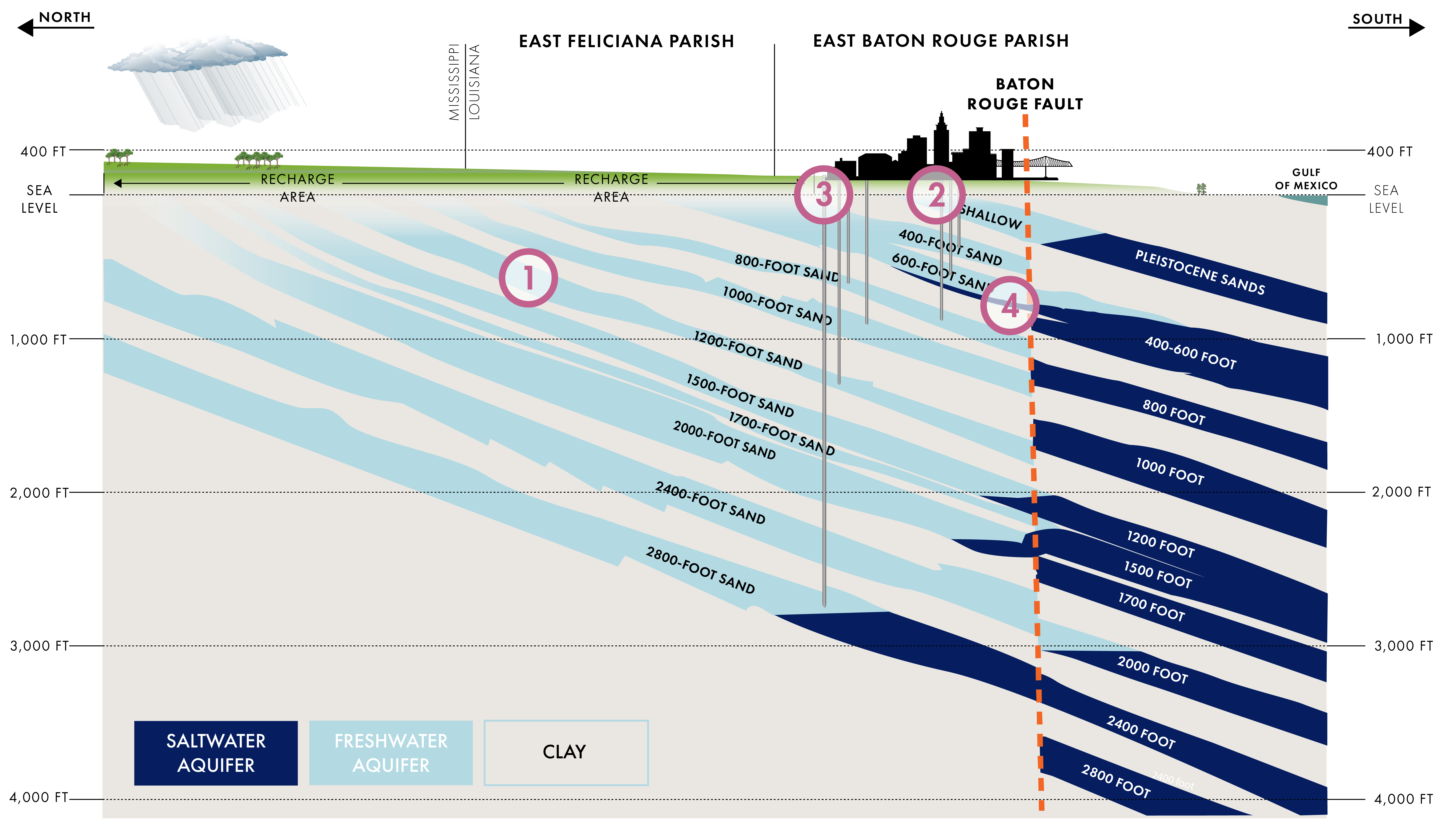
The Southern Hills Aquifer System covers approximately 14,000 square miles of southeast Louisiana and southwest Mississippi. It is a system made up of alternating layers of water separated by barrier materials much like a layer cake. There are as many as 13 layers that contain water throughout the system, but in Baton Rouge, there are only 10 that are recognized as important for public consumption and industrial use, with the majority of water for public consumption sourced from the 1,500 and 2,000-foot aquifer layers ("sands"). Fresh water drawn from the Southern Hills Aquifer System provides 100% of the public water supply and 83% of the industrial and power generation water supply in East Baton Rouge Parish.
Processes in the Southern Hills Aquifer System
WHAT IS SALTWATER INTRUSION?
The first indication of saltwater intrusion was detected in the Southern Hills Aquifer System in 1950 when chloride levels, which are used to determine salt levels, were found to have surged from seven parts per millions (ppm) in 1943 to 710 ppm in one well in the "600-foot Sand" aquifer.
In 2007, USGS published a study that revealed eight out of the ten major aquifers showed an increase in chloride levels in the Greater Baton Rouge area .
There are two theories on how this salt water is getting into the water of the Southern Hills Aquifer System. One theory suggests that salt water from rock salt formations is migrating to the Southern Hills Aquifer System through nearby sands. Another emphasizes the intrusion of salt water as brine from subsurface salt domes into the Southern Hills Aquifer System through a geologic fault.
There are multiple geologic faults that run east-west across Louisiana. A fault is the boundary between two blocks of sediment/rock along which the blocks move relative to one another. The faults in Louisiana are not known to cause earthquakes, but some of these faults are active, causing movement of the sediment blocks.
Two of these active faults intersect the Southern Hills Aquifer System. In northern East Baton Rouge Parish, the Denham Springs – Scotlandville Fault stretches from the Mississippi River east to Livingston Parish. To the south of East Baton Rouge Parish, the Baton Rouge Fault follows a similar east-west path. The Baton Rouge Fault is of particular importance as it acts as the boundary between the fresh water of the Southern Hills Aquifer System to the north of the fault and the salt water that lies beneath the Mississippi Alluvial Valley south of the fault. But the slow movement of the sand and clay units that is created by the Baton Rouge Fault causes this boundary to leak and provides the capacity for salt water to enter the freshwater Southern Hills Aquifer System.
How is that salt water moving north?
As water is pumped out of the aquifers for public and industrial use, the recharge rate – the amount of water entering the aquifers through the recharge area – doesn’t keep pace with the amount of water being withdrawn. This imbalance means that when groundwater is withdrawn, that action essentially pulls salt water across the fault line from south to north, and moves the salt water closer to freshwater wells. The rate of saltwater intrusion varies, dependant on a number of factors including how much water is extracted from aquifers north of the Baton Rouge fault and which aquifer layer is being used.
What can be done to slow or stop the saltwater intrusion?
In recent years there has been a tremendous investment in research to support better understanding and effective management of the Southern Hills Aquifer System. A number of changes have occurred in the management of the aquifer system, including the lowering of groundwater withdrawal caps and the implementation of mitigation technologies.

In 1999, a connector well was installed to connect two aquifers beneath Baton Rouge. This connector well delivers water from the 800ft sand (aquifer layer) to the more vulnerable 1500ft sand, which is used heavily for public supply. By supplementing the volume of water in the 1500ft sand the risk of saltwater intrusion into the Government Street well in Baton Rouge is reduced.
A scavenger well was installed in 2014 in the 1500ft sand to protect Baton Rouge Water Co.'s Lula Street Pumping Station. This scavenger well is intended to slow the intrusion of chlorides into the drinking water well at that location through the removal of salt.
Other proposed physical mitigation techniques include the closure or movement of individual wells or well fields and creation of injection wells to alter pressure dynamics along the fault zone to essentially push the salt water back.
Additionally, reduced freshwater withdrawals may extend the life of the freshwater supply. Historically, water levels in the aquifers have varied with usage and reduced pumping. With reduced freshwater extraction and adequate recharge there is the potential for reducing the subsidence and subsurface depressions that have occurred around wells as a result of heavy withdrawals.
There are a number of fresh water alternatives to the Southern Hills Aquifer System, however all would involve the creation of additional infrastructure to treat the water for use. Most notably, surface water from the Mississippi River is already used by some industry in the region and has long provided the public water supply for New Orleans.
Additional Research is Needed, and Underway
To provide the best available science to inform decision makers, additional research is ongoing to provide a more comprehensive understanding of the Southern Hills Aquifer System. A fundamental component of effective management of the Southern Hills Aquifer System is to have a thorough understanding of the water supply and demand. While significant numerical modeling efforts have been undertaken, reliable water budgets for each individual sand layer at a district-wide scale are still being developed. This full picture is needed in order to make fully informed management decisions to ensure the sustainable, long-term supply of water.
A significant component of understanding the available supply of water is having a comprehensive understanding of the efficacy of potential saltwater mitigation, groundwater conservation, and alternative supply sources. There are mitigation measures currently in place, and data from those measures could, where available, help provide greater understanding on the most efficient ways to mitigate saltwater intrusion. Identification of water loss within the system could help to support the development of groundwater conservation measures. Alternative supply sources, such as surface water from the Mississippi River, are already used for industrial purposes in the Baton Rouge area and additional work is being conducted to evaluate alternatives.
Additionally, there remain unknowns regarding the geology of the Southern Hills Aquifer System. Subsidence has previously been observed to be a combination of both the aquifer's cone of depression and of regional processes, and additional monitoring could support greater understanding as to the relative influence of these varying factors. There are also different interpretations of the geology of the Southern Hills Aquifer System, and the work underway is supporting updates of the geological interpretation. Given the difficulty and cost associated with spatially analyzing a geologic fault with high certainty, alternative investigative methods may be necessary in the future.
Overview of the 1,500-foot and 2,000-foot sands
The 1,500-foot and 2000-foot sands are historically two of the most heavily used aquifers in the Southern Hills Aquifer System, and research and monitoring has long shown that these two aquifer sands are at particular risk from saltwater intrusion.
The 1,500-foot Sand
Due to its role in public water supply, the 1,500-foot sand is one of the most well-documented and studied aquifer layers in the Southern Hills Aquifer System. In 1975, the newly formed CAGWCC passed a resolution that allowed the 1,500-foot sand (along with the 1,000- and 1,700-foot sands) to be used only for public supply. Pumpage from the aquifer was around seven billion gallons per year between 1990 and 2010 and has declined since. The majority of pumpage from this aquifer today is for public supply (CAGWCC, 2019). In the first half of 2020, 1.79 Mgal/d was pumped from the aquifer by industrial users and 10.6 Mgal/d for public supply. This usage reflects a slight reduction from 2018.
Potentiometric Surface
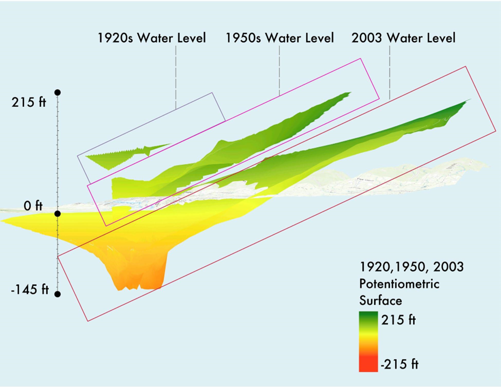
The potentiometric surface of an aquifer is an imagined plane at an elevation to which water would flow upwards if it were not restricted by the dense clay units of a confined aquifer. When water is withdrawn from an aquifer faster than it can recharge, this potentiometric surface will lower. Research by Prakken (2004) and USGS (2020) found that between 1920 and 2003, the potentiometric surface of the 1,500-foot sand has declined substantially with the largest drawdown, -145-feet, seen in the Baton Rouge Industrial District. While water withdrawals from the 1,500-foot sand have been reduced, analysis by Heywood (2019) did not show any increase in potentiometric surfaces. A 2015 modeling scenario by USGS, however, predicted a 15-20 foot water level rise over 50 years in the 1,500-foot sand if seven wells in the northwest corner of the industrial district were to cease operations.
Saltwater Intrusion
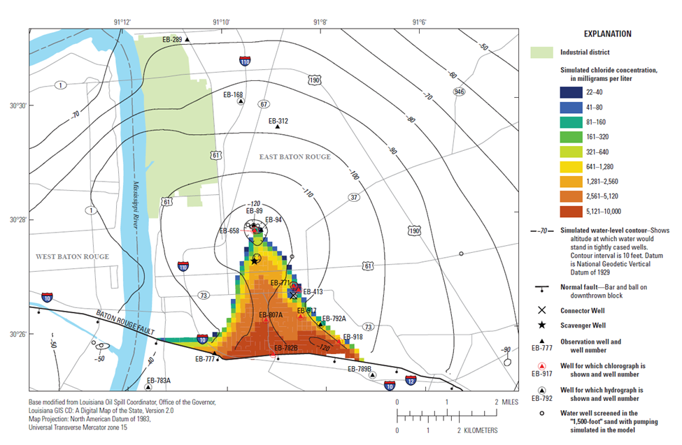
As the potentiometric surface of the 1,500-foot sand has decreased, chloride concentration levels have increased. In 1955, Meyer & Turcan Jr. documented chloride levels of <4ppm (~<4 mg/L) in the 1,500-foot sand. Saltwater intrusion was first noted in the aquifer unit in the 1970s. In 2004-2005, chloride levels of 1,010 mg/L were recorded in the 1,500-foot aquifer, and a study by Lovelace, (2007) determined that this saltwater intrusion affects an area from "Port Allen to Tiger Bend, and north to Industrial District."
Saltwater Mitigation
The 1,500-foot sand is the focus of two significant mitigation efforts. The first is a connector well installed in 1999 to hydraulically connect the 800-foot aquifer to the 1,500-foot aquifer. This well helps mitigate the differences in potentiometric surface north of the Baton Rouge Fault, and help prevent saltwater intrusion at the Government Street water wells. The second mitigation effort was the implementation of a scavenger well in 2014 to prevent saltwater intrusion at Baton Rouge Water Co.'s Lula Street Pumping Station. This scavenger well acts as a syphon, using differential pressures to separate salt water from fresh water. Modeling of the scavenger well by USGS and LSU suggests that there are beneficial results for the 1,500-foot sand beyond Lula St., but monitoring data from the scavenger well are limited.
The 2,000-foot Sand
The 2,000-foot sand is also a historically heavily utilized aquifer, though unlike the 1,500-foot sand, the 2,000-foot sand provides a significant source of water for industry and power generation in addition to public supply. The aquifer has been subject to CAGWCC withdrawal caps since 1991, and withdrawals were further limited in 2013 to a rate of 17.5 Mgal/d for the Baton Rouge Industrial District. As a result of the caps, and additional measures by CAGWCC to develop alternatives in 1999, withdrawals from the 2,000-foot aquifer have reduced from around 12.5 billion gallons per year in 1980 to between eight and nine billion gallons per year by 2019 (CAGWCC 2019). In the first half of 2020, an average of 4.8 Mgal/d was withdrawn by industry, another 7.93 Mgal/d was pumped for power generation, and 5.11 Mgal/d was withdrawn for public supply. These numbers reflect a slight decline in usage for industry and power generation from 2018, while pumpage for public supply has largely remained steady.
Potentiometric Surface
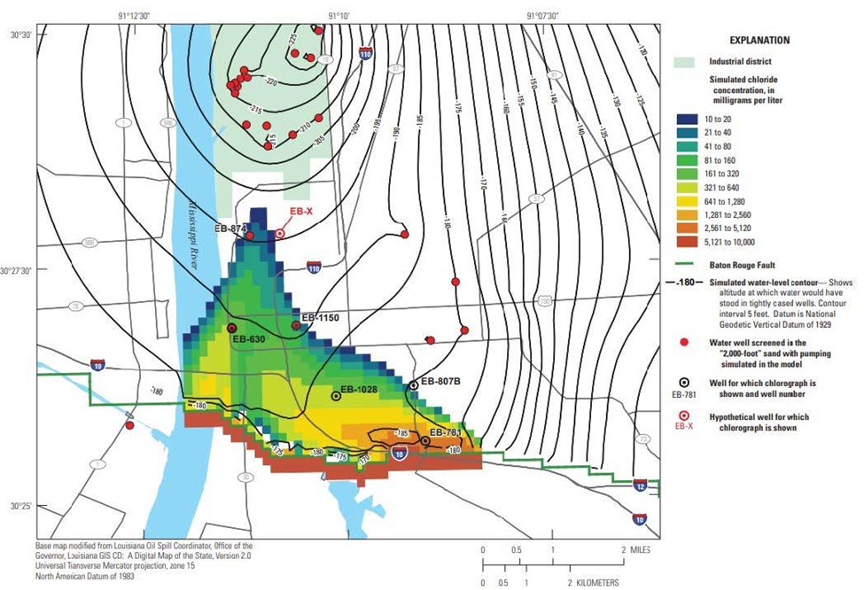
There is a clearly delineated cone of depression centered around the Industrial District in Baton Rouge (shown in the 2012 simulated water-level contour from Heywood [2015]). The centermost, lowest point of this potentiometric surface is believed to be around -220 ft, representing an overall drop of 356 ft. The partial shut-down of Georgia-Pacific in 2019 is expected to provide valuable information about the ability of aquifers to recover, with a USGS monitoring well in the 1,700-foot sand, approximately one-mile east of Georgia-Pacific, showing a 50 ft increase in water levels since 2019, following 100 ft of drawdown between the 1960s and 2019.
Saltwater Intrusion
Historically, chloride concentrations in the 2,000-foot sand have been observed as lower than those of the 1,500-foot aquifer. Lovelace (2007) noted that saltwater intrusion was first observed in the 1960s, and by 2005-2006 had been recorded at 266 mg/L affecting an area that covers the Baton Rouge Fault to the Industrial District (a south-to-north distance of around three miles). The chloride concentrations are vertically stratified, and modeling predicts that levels are higher at greater depth in the aquifer. Modeling by Heywood (2015) indicated the presence of a broader saltwater wedge than in the 1,500-foot sand.
Saltwater Mitigation
CAGWCC has recently proposed that a scavenger well be installed in the 2,000-foot well, with USGS and LSU modeling predicting similar beneficial impacts as those predicted for the 1,500-foot scavenger well. This 2,000-foot well would be placed between the Baton Rouge Fault and the Industrial District.
Groundwater Usage Across the Capital Area Groundwater Conservation District

Beginning in 2018, there is a notable reduction in groundwater usage by industry within the District. This reduction is largely attributable to the partial shut down of the Georgia-Pacific facilities in East Baton Rouge Parish.
In the period 2018-2019, Georgia-Pacific reduced their usage by 6,277 Mgal, which represents 78% of the reduction in industrial use across the District. In 2019-2020, Georgia-Pacific reported a further reduction in usage of 3,782 Mgal, which was 97% of the total reduction in industrial use across the District.
In light of this change in withdrawals for industrial supply in East Baton Rouge, the Parish's overall groundwater usage has reduced, and the proportion of withdrawals by user type is currently similar to those seen across the rest of the District.
Groundwater Usage within East Baton Rouge Parish
