Crowdsourced Bathymetry
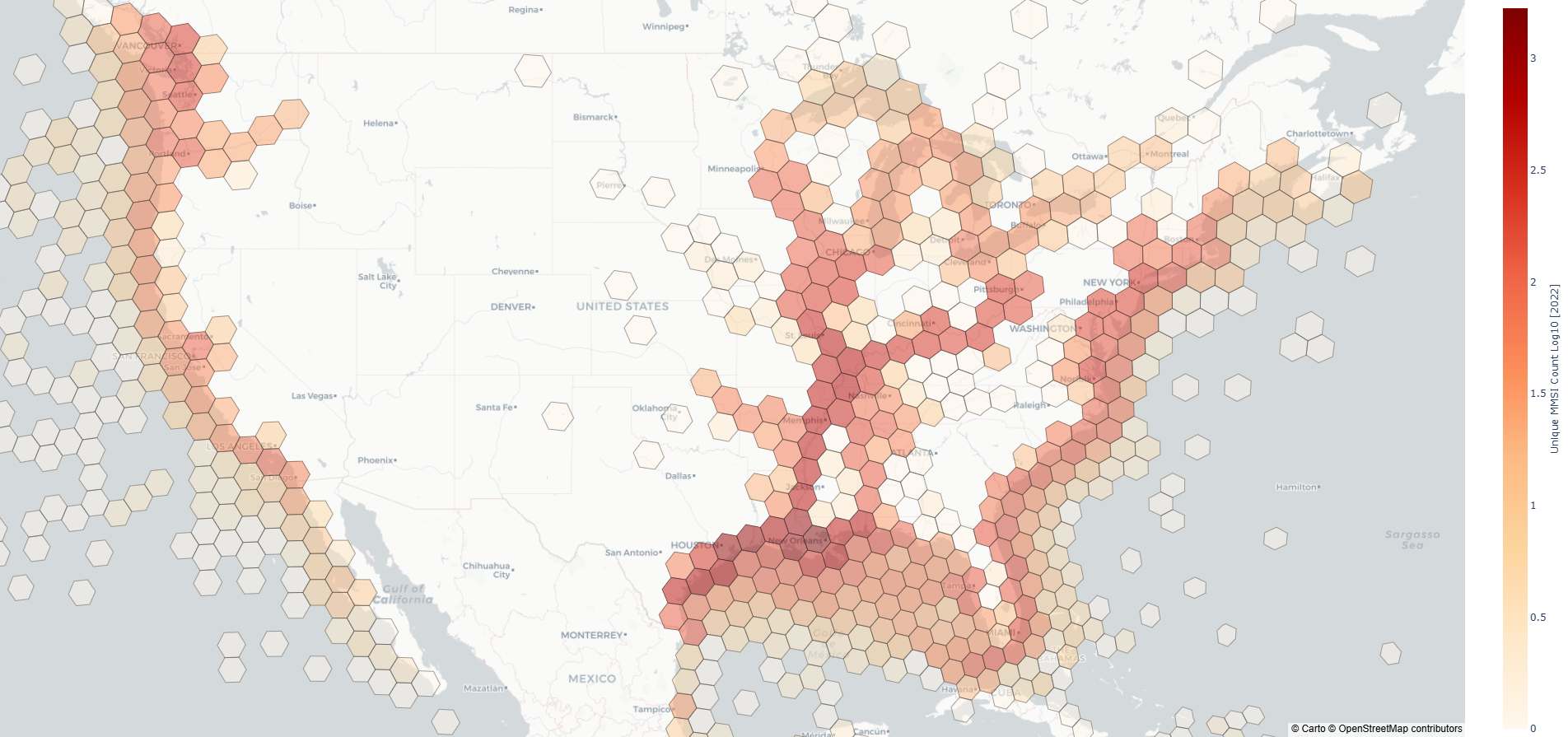
Crowdsourced bathymetry (ShoalCast) transforms routine vessel operations into a continuous source of channel intelligence. By leveraging positioning and depth measurements from everyday working vessels, such as tugs and towboats, we produce near real-time maps of channel conditions across inland and coastal waterways (see viewer below). We work to improve how waterways are monitored and managed by applying practical data-driven approaches to address real-world maritime issues.
Unlike traditional hydrographic surveys, which provide intermittent snapshots, crowdsourced bathymetry has the capability to deliver persistent visibility into channel conditions over expansive areas.
This novel approach can support more efficient navigation and operations, and better informed decision making.
For best results, view the CSB portal below on desktop.
Program Contributors
The organizations shown below have contributed to the crowdsourced bathymetry program over time, including both active and past participants. Their voluntary participation supports improved understanding of channel conditions and helps advance practical approaches to navigation and waterway management.
How it Works
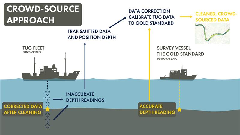
Institute-developed software is deployed remotely to a vessel’s PC that gathers positioning and depth information. These data are quality controlled, corrected to a common vertical datum (i.e., NAVD88) using historical hydrographic surveys and water surface elevation, and aggregated spatially and temporally to produce anonymized surfaces of channel conditions (e.g, bed elevation or available draft).
Relationship to Hydrographic Surveys
Crowdsourced bathymetry is not a replacement for traditional hydrographic surveys. Dedicated surveys remain essential for charting, engineering design, and regulatory decision making.
Crowdsourced bathymetry is intended to complement survey programs by providing temporal and spatial continuity between survey cycles. Additionally, hydrographic surveys are a cornerstone for providing corrections to crowdsourced data.
What CSB Offers
Crowdsourced bathymetry supports multiple levels of insight, depending on user needs:
- Historical channel conditions: With years of historical data, insights into how channel conditions evolve over time is possible.
- Near real-time channel monitoring: Ability to track emerging shoals or degradation as changes develop
Operational Use Cases
- Identifying areas where available draft is approaching operational thresholds
- Targeted hydrographic survey planning
- Voyage planning
- Disaster response
- Improved coordination across stakeholders
Built for Scale
The inland waterway system supports an active fleet of more than 5,000 tugs operating nationwide. Our current crowdsourced bathymetry program includes an active network of approximately 60 participating vessels, demonstrating how routine operations can be leveraged to generate meaningful channel insight. Because most working vessels already carry the necessary positioning and depth-measurement equipment, participation can expand readily as additional operators volunteer, allowing spatial coverage and data density to increase naturally in the areas where vessel traffic is highest.
Get Involved
Interested in participating in the crowdsource fleet or learning more about crowdsourced bathymetry? Sign up for The Water Institute email list below.