Integrated modeling to answer complex water/land interaction questions
The Challenge
Addressing how water and land interact, particularly when dealing with large-scale and complex systems, is essential for evaluating how projects will perform and achieve multiple goals.
This work includes the evaluation of Engineering with Nature (EWN) approaches, which has become an important and active field of applied research. The U.S. Army Corps of Engineers (USACE) Engineer Research and Development Center (ERDC) defines EWN as the intentional alignment of natural and engineering processes to deliver economic, environmental, and social benefits efficiently and sustainably. Read more about the work here.
The Mississippi River brings freshwater and sediment into the delta of Louisiana, providing an opportunity to evaluate EWN concepts at large scales, both geographically and over time, a vital need as Louisiana faces a coastal land loss crisis. In response, the Institute has been working with state and federal partners to better understand the complex connections between water and land in ways that consider flood risk management, navigation needs, and sustainable habitats.
Evaluating how the landscape changes in response to infrastructure or coastal restoration work involves complex interactions among land, water, fisheries habitat, vegetation, and communities. Each of these components changes and evolves based upon changes in another component.
The Approach
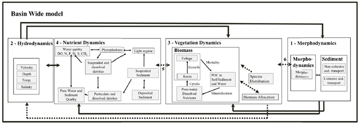
To address these challenges and assist decision makers in assessing alternative infrastructure development and operation, the Institute developed an integrated modeling system for restoration projects in coastal Louisiana called the Basin Wide Model.
The model has been continuously improved over the last decade with the most current version bringing together morphodynamics, hydrodynamics, vegetation, and nutrient dynamic models that interact with each other on a decadal scale over a 50 years in the Mississippi River and proximal basins.
Used to analyze different environmental scenarios and operational regimes of the Mid-Barataria Sediment Diversion project, one of the largest ecosystem restoration projects in the country, the numerical modeling system designed by the Institute allowed the Louisiana Coastal Protection and Restoration Authority (CPRA) and regulators at agencies like USACE to evaluate not only the land-building capabilities of the diversion, but also how that land building would interact with so many other environmental factors.
Louisiana recognized early on in it’s planning process that designing something on the magnitude of a large sediment and water diversion from the Mississippi River needed to maximize science in order to minimize politics.
Through this highly integrated modeling approach, as land changes occurred, hydrology changed along with salinity in the estuaries which impacted the extent and type of vegetation which, in turn, affects hydrology and sediment transport, and habitat changes. The model accounted for this interactions over a 50-year period. In addition, Basin Wide Model landform change, water quality, and other projections were used to inform other models that were key to support decision making, such as habitat suitability models and models to assess future flood risk for high tide flooding and tropical storm events.
Decision-support
Making decisions around large infrastructure and environmental restoration projects doesn’t begin and end with numerical modeling. The Water Institute’s interdisciplinary team brings together multiple facets of the challenge to arrive at a more holistic answer. This team includes planners and researchers who have been the principal investigators for the Coastal Louisiana Risk Assessment (CLARA) modeling effort which provides next-level modeling capabilities for Louisiana Coastal Protection and Restoration Authority to efficiently estimate flood risk under a wide range of future environmental, operational, and growth uncertainties, and with various proposed projects in place. The Institute also has subject matter expertise in ecology, geosciences, hydrodynamics, sediment dynamics, and morphology, that routinely support the translation of complex modeling output and information, creating customized data analytics to inform project valuation among various alternatives.