Deepwater Horizon Louisiana Trustee Implementation Group (TIG) and Regionwide TIG
Avian Monitoring
Gulfwide Avian Monitoring and Restoration Guidance
Ongoing
The Challenge
In 2010, the Deepwater Horizon explosion resulted in the largest oil spill in United States history discharging millions of barrels of oil into the Gulf of Mexico. In the wake of the spill and subsequent settlements, federal and state agencies were tasked with assessing and restoring damage. Part of that work involved analyzing and quantifying injuries to bird habitats and populations along the northern Gulf of Mexico.
The Approach
The Water Institute is working with the Deepwater Horizon Louisiana Trustee Implementation Group (TIG), the Regionwide TIG, and partners across several projects to help inform coastal restoration for birds and assess nesting bird populations using aerial survey photos dating from 2010 onward.
Guidance for Coastal Ecosystem Restoration and Monitoring to Create or Improve Bird-Nesting Habitat
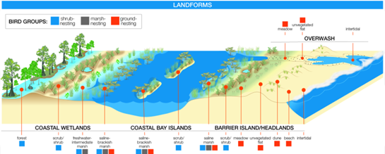
The Water Institute developed the “Guidance for Coastal Ecosystem Restoration and Monitoring to Create or Improve Bird-Nesting Habitat,” for the Louisiana TIG. The guidance builds upon the high-level goals and strategic frameworks of Natural Resource Damage and Assessment, the Louisiana TIG, and the Gulf of Mexico Avian Monitoring Network Strategic Bird Monitoring Guidelines, and is intended to inform ecosystem restoration design that benefits nesting birds, provided at the scale of an individual ecosystem restoration project.
The primary audience for the guidance document is ecosystem restoration project teams and is intended to be used during planning, designing, implementing, and monitoring of projects.
The guidance was the result of extensive collaboration including more than 100 facilitated calls and working sessions over a period of more than two years. This effort included input from bird experts, coastal restoration project managers and engineers, and state and federal representatives.
More information about the project here.
Avian Data Monitoring Portal
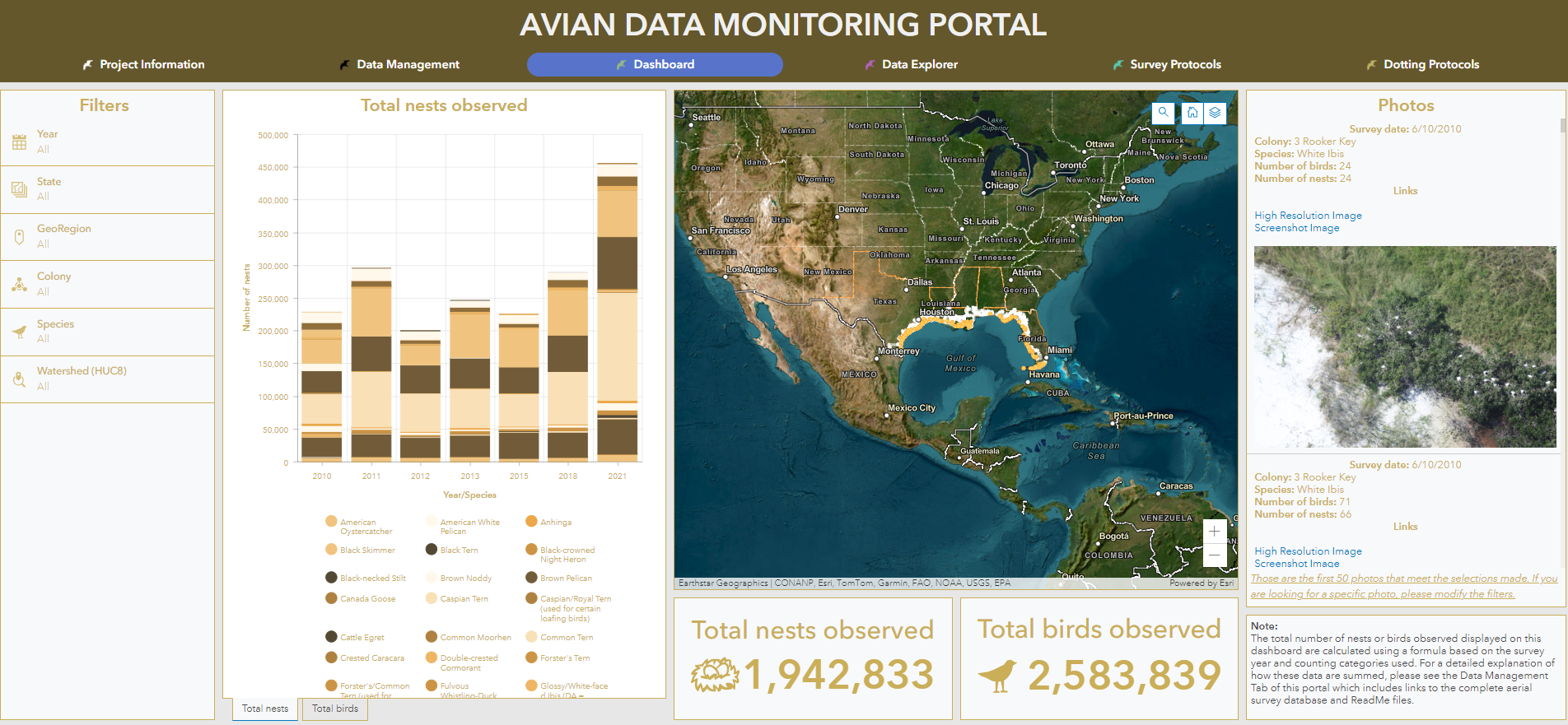
Starting in 2010, Colibri Ecological Consulting, a partner with the Deepwater Horizon Regionwide TIG, began collecting aerial survey photos along the Gulf of Mexico coastline to document nesting bird colonies. This effort resulted in more than 49,000 photographs that were then “dotted” by Colibri to count the species and nests across the survey area.
The Water Institute, supported by the Regionwide TIG, compiled these photographs and the associated dotting data into a web-based, geospatially enabled portal that is searchable and accessible for interested end users. The Avian Data Monitoring Portal links Environmental Systems Research Institute (Esri) Enterprise Geographic Information Systems (GIS) software with a Web Mapping Service (WMS), and the aerial survey photo database to create a dashboard for easier navigation to explore total nests and birds observed over various geographical areas and time scales.
The work fulfills the need expressed by Louisiana Coastal Protection and Restoration Authority’s (CPRA) Statement of Need titled “Deepwater Horizon Regionwide Trustee Implementation Group Monitoring and Adaptive Management Activity Implementation Plan: Colonial Waterbird Monitoring.” The Water Institute developed this application to publicly distribute the data collected, processed, and analyzed by this project from 2010-2021.
Access the Avian Data Monitoring Portal here.
Watch a walkthrough of how to get started with the Avian Data Monitoring Portal here.
KEY TEAM MEMBERS


Director of Research Operations/Director of RESTORE Act Center of Excellence for Louisiana
VIEW TEAM MEMBER